Frequently asked questions (FAQs)
Accessible options for this consultation
- assist with understanding the documents
- provide alternative formats if required
- and arrange interpreter support.
- learn more about the Study.
- understand how to access maps and information.
- ask general questions and share feedback with the project team.
- speak directly with Council staff and project specialists.
- explore the revised Draft Study in greater detail.
- discuss property-specific or technical questions.
- review mapping and supporting information.
- share feedback with the project team.
- only use your email address to provide updates or invite you to participate in consultations if you choose to opt in during registration
- not share your personal details with third parties or use them for any other purpose
- manage your information in-line with applicable privacy laws and Council policies.
Is this consultation accessible?
Council recognises the importance of accessibility and inclusion in engagement and we are committed to continuously improving in this area to make engaging as easy as possible for all in our community.
Our team are available to:
Maps of the Study area are available online and in printed formats at our Administration Building Customer counter and 7 libraries within the catchment area. Customer and Library staff can help you use the maps to identify your property.
A printable copy of our consultation FAQs is also available, should you prefer in this format.
If you need support to provide feedback during the exhibition, please reach out to the Community Engagement team on:
Email: engagement@ssc.nsw.gov.au
Phone: 02 9710 0333
Pop-up and information sessions - what's the difference?
Whether you'd like a quick chat with the project team or the opportunity to explore the revised Draft Study in more detail, we're offering a range of opportunities to learn more, ask questions and share feedback.
Community pop-up sessions provide an informal opportunity to:
Community information sessions provide a more detailed opportunity to:
All are welcome. We are committed to making participation accessible and inclusive.
If you would like to discuss alternative ways to provide feedback or require assistance to participate, please contact us on 02 9710 0333 or via engagement@ssc.nsw.gov.au
How can I find out more about how my privacy is protected?
Your privacy is important to us. It is protected by both Council and our online engagement provider, Granicus, which delivers the Join the Conversation platform.
Council will:
Granicus is also required to handle your information in accordance with privacy and security requirements.
You can read more about how your information is collected, stored and used by reviewing Council’s Privacy Policy, available on our website.
About the Study
- Reviewed and considered all feedback received, including feedback about the Draft Study and opportunities to improve the way we engage and communicate.
- Conducted field inspections to verify model inputs such as piped infrastructure, ground levels and building footprints. The verified information was used in the updated flood model.
- Engaged an independent peer reviewer to confirm that modelling parameters are consistent with current best practice.
- Updated the rainfall data to align with current technical advice from the Australian Government under Australian Rainfall and Runoff Guidelines.
- Reduced the freeboard applied to the flood planning area from 500mm to 300mm
- Undertook a detailed review of model results to identify irregularities, followed by targeted site inspections to verify (sometimes called “ground-truth” in the Study) and validate the data.
- Reviewed properties identified in this Study as flood affected within the planning layer.
- Worked directly with affected residents to answer questions and provide support throughout the Study.
- Flood lot notations have been reviewed and some removed. For example, properties along the foreshore that do not experience overland flooding but are identified as flood-affected from rising water levels within large waterways (such as the Georges River or Port Hacking), have been removed because these properties have sufficient foreshore controls to protect development of these areas without additional lot flood notations, and this aligns with the Study’s methodology and intent.
- Reviewed filtering parameters to ensure that very shallow or isolated ponding, and minimally impacted lots, are not included in the planning layer – in line with the intent and methodology outlined in the Study’s report.
- Confirmed the planning layer accurately captures continuous flow paths so that consistent controls apply along each flow path.
- Increased the Study area to capture flood risk for small urban areas within the four major catchments that were not included in the initial Draft Study.
What is an overland flood study?
An Overland Flow Flood Study looks at how rainwater flows across the ground during different types of storms. It shows where water is likely to travel, how deep it may get, and which properties, roads, and other infrastructure could be affected.
To do this, engineers collect information about the area, including the shape of the land, buildings, roads, vegetation, and Council's stormwater drainage system such as pipes, pits and culverts.
This information is then entered into a computer program, which simulates how water moves across the landscape during different rainfall events. The model is tested and refined using information from past floods, including photos, videos, flood marks and observations collected by Council, the State Emergency Service and local residents. Community feedback is valuable because it helps improve our understanding of how flooding behaves in real storms.
The flood model can be used to estimate flood depth, flow speed and the extent of flooding for a range of storm events, from common storms to rare and extreme events.
The Study helps Council understand flood risks across the community. This information can then be used to improve flood planning, emergency management, infrastructure design and future development decisions.
Why do councils prepare flood studies?
In NSW, councils are responsible for local stormwater drainage and are primarily responsible for managing flood risk to their communities. The NSW Government provides councils with technical and financial support to manage the flood risk through the Floodplain Management Program provided by Department of Climate Change, Energy, the Environment and Water (DCCEEW). The Program exists to understand and reduce the impacts of flooding and flood liability on communities and individual owners and occupiers of flood prone property.
As part of the Floodplain Management Program, councils develop and implement flood risk management plans consistent with the NSW Flood Risk Management Manual (2023). Flood Risk Management Plans outline how councils plan to manage flood risk in the area including any feasible recommended measures, such as upgrading stormwater drainage systems.
Flood studies are the first key step in developing a flood risk management plan. They develop information about flood behaviour to help Council, Government, and the community understand flooding, so they can be informed about flood risks when making decisions and in responding to flood events.
Flooding in the Sutherland Shire can result from rivers, creeks or the coast, however, the most common flooding which residents experience is overland flow flooding. ‘Overland flow’ typically occurs when rainwater flows over a surface, such as lawns, roads, roofs, car parks and natural areas, on its way to the nearest drain, creek or river. Overland flow flooding can occur during heavy rainfall when stormwater systems temporarily cannot capture all runoff, causing water to flow across natural low points in the land, open channels and drains, roads and footpaths public reserves and even private property.
Why is studying overland flooding important?
The first step in managing flood risk is to identify where the risks currently exist. Overland flow can cause flooding, damage to property and create safety risks. Importantly, it can affect areas not typically considered at risk, such as properties on hills or far from creeks or rivers.
These risks are considered in planning for future development and in the design of homes and infrastructure, including improved drainage and higher building levels to reduce flood damage. The information also provides important information to emergency services such as the NSW State Emergency Service (SES).
How was the Draft Overland Flow - Flood Study for Sutherland Shire prepared?
The NSW Government provides the NSW Flood Risk Management Manual and Guidelines to help councils and experts carry out flood studies, for all kinds of floods including riverine, coastal and overland flow.
Council has engaged BMT, a specialist flood consultant, to prepare this Flood Study. BMT has completed similar studies for other councils across NSW using these guidelines.
The study is overseen by the Flood Risk Management Committee. This group includes community representatives, Sutherland Shire Councillors and technical experts from the NSW Government, the SES and Council.
The first step in managing flood risk is to identify where the risks currently exist. Flood modelling was carried out to understand how water flows during different types of storms. This included checking the model against data from past flood events to improve accuracy. It looked at a range of rainfall events, from smaller, more frequent storms through to rare and extreme events. It also considers potential changes in climate to understand how flood risk may look in the future.
Once modelling was completed the mapping was adjusted so that very shallow depths and/or low velocities of flow are not mapped because these do not pose a risk to people or properties. This process is called “filtering”. Filtering criteria was used to finalise flood mapping to ensure that flood extents are consistently applied based on a risk management approach. Using filtering criteria ensures that properties that experience overland flow are identified so that risk can be managed in development and property protection.
An adopted Overland Flow – Flood Study can be used to prepare Flood Risk Management Studies and Plans, which would allow Council to better manage flood risk for our community. Studies prepared under the NSW Floodplain Management Program may also be eligible for government funding to assist in carrying out important flood mitigation works.
Project milestones and key dates
| Date | Project milestone |
Oct 2023 to Mar 2024 | Public exhibition of 2023 Draft Sutherland Shire Overland Flood Study. |
Apr to Aug 2024 | Council review of more than 2,180 community submissions and initiation of regular updates for community members who received initial letter notifications. |
Aug to Dec 2024 | Carried out site inspections at over 60 key areas identified by community feedback and updated the model using new rainfall guidance published in 2024. |
Jan to Jul 2025 | Updated the flood model using the improved data from site inspections, regularly updating the Flood Risk Management Committee. |
Aug to Nov 2025 | Completed further site inspections, refined the study further and began developing an improved communication and engagement approach. |
Dec 2025 to Feb 2026 | Updated the model based on second round of inspections, started the independent expert review. |
Mar to May 2026 | Finalised the technical updates based on the expert review and conducted final round of inspections. |
Jun 2026 | 2026 Draft Study and report, including results of independent expert review, presented to Flood Risk Management Committee. Committee recommended the revised Draft Study progress to stage two of public exhibition. |
Jul 2026 | Council resolved to place the 2026 Draft Study on public exhibition. |
| Jul to Sep 2026 | 2026 Draft Study on public exhibition |
| TBC | Final Study to be reviewed by Council and considered for adoption. |
Was there a previous consultation stage for this Study?
Yes, the first Draft Overland Flow - Flood Study was exhibited in October 2023 to March 2024.
The insights and lived experiences received from our local community during the first consultation phase were central to considerations that have shaped our 2026 Draft Study, helping to plan for a more resilient future for everyone.
Click here to see the previous draft Study exhibition webpage
We are now looking forward to speaking with our community about our current 2026 Draft Study, answer questions and capture all feedback as we continue to work with our local community and stakeholders to finalise the Study.
What has progressed since the first stage of consultation for the Study?
Since the first stage of consultation on the Draft Study, the project team have taken the following actions:
What are the “flooding hotspots” shown in the Study?
The hotspots were identified using a combination of flood modelling, Council records, NSW State Emergency Service (SES) incident information, community feedback and observations from historical flood events. The model results were compared against this information as part of the process of checking that the model provides a reasonable representation of observed flood behaviour.
A flooding hotspot does not mean that flooding only occurs in these locations, or that all properties within a hotspot will experience flooding. The hotspots are simply locations that were used to understand flood behaviour across the Study area and to help communicate where overland flow flooding is known or predicted to occur.
About flooding
What is 'overland flow flooding?'
Overland flow is where water from rainfall flows across the land on its way to major drainage systems, such as creeks and rivers. All properties will have some overland flow in heavy rain, even those located on hillsides. Overland flow becomes overland flooding when the flow is deep enough and/or running fast enough that it may pose a risk to life or property.
Overland flow flooding can occur when heavy rainfall is so intense that the stormwater drainage system cannot cope with the volume of water, or when drains become blocked. Stormwater systems are rarely able to be designed to cater for all rainfall events. When the amount of rainfall exceeds the capacity of the drainage system, excess water flows over the ground and follows the low points in the land as it makes its way toward creeks and rivers.
Ideally, this water travels along roads and gutters, however at low points when drains are at capacity water can build up, overtop the road verge and flow across parks, public land or private property. In many cases there are drainage easements that allow for overland flow, but water can also pass around buildings, fences and other obstacles. In some cases, water may enter homes, garages or basements.
Overland flow flooding, sometimes referred to as flash flooding, occurs most often during sudden and intense rainfall events with little warning. Although it is typically short-lived and usually subsides once rainfall eases, it can disrupt traffic, isolate properties and cause damage to buildings located within flood paths or not elevated sufficiently above expected flood levels.
My property hasn't been flood affected before. Why is my property identified in this Study?
Flood studies identify land that may be impacted in relatively rare events. Just because you have not personally experienced flooding at your home before does not mean that it is not at risk. Every flood is different and how the flood behaves will depend on many variables which are considered as far as possible when floods are modelled.
The Overland Flow – Flood Study models various rainfall scenarios, with two scenarios used to identify risk and help owners, developers, Council and Emergency Services plan for the future.
The first of these is known as the 1% Annual Exceedance Probability (1%AEP) flood. This is a flood that has a 1 in 100 chance of occurring at any time.
We use this to determine a Flood Planning Area (FPA) which uses the 1%AEP flood level and adds a 'freeboard' allowance, which provides an additional margin of safety to reduce the likelihood of a home or business becoming flooded.
We also use the Probable Maximum Flood (PMF) which represents the largest possible flood event that could occur in a particular area. While extremely rare, the PMF is used to understand the maximum extent of flooding and identify risks to life and critical infrastructure during extreme events.
Why doesn’t Council’s stormwater drainage prevent overland flooding?
Council’s stormwater system includes drains, pits, pipes and open channels. Like all underground drainage, it is designed to handle smaller, more frequent rain events so people aren’t dealing with puddles every time it rains. During larger storms, the system cannot capture all the water. When this happens, excess water flows over the ground, this is 'overland flow'. Roads and valleys are often the main paths that this water follows, and open channels can often manage larger flows, but these cannot be placed everywhere.
It is not always possible or cost-effective to upgrade the drainage system to handle every storm. However, Flood Studies help identify problem areas where improvements may be needed. Follow up Flood Risk Management Studies & Plans can then assess whether upgrades to drainage could reduce flooding and improve safety.
Ideally, excess water flows along roads, through parks or along drainage easements. However, water will always follow the lowest points in the landscape. These low areas are often where natural creeks or drainage paths existed before development.
Where these flows are not well managed, it is important to identify them so that options for improvement can be explored.
What is a 'probable maximum flood' (PMF)?
The Probable Maximum Flood (PMF) represents the largest flood that could realistically occur in a particular area. It is an extremely rare event resulting from the most severe combination of rainfall and catchment conditions considered physically possible. While extremely rare, some floods in Australia have approached the scale of a PMF event.
The PMF is used to understand the maximum extent and depth of flooding that could be experienced and to identify potential risks to life, property and critical infrastructure during extreme flood events. The PMF extent is generally considered to define the full extent of the flooding and areas outside of this are not considered flood affected.
The PMF is used by councils, engineers and emergency management agencies to assess extreme flood risks, support emergency planning, consider the safety of evacuation routes and inform decisions relating to vulnerable or sensitive development.
What is the 'Flood Planning Area' (FPA)?
The Flood Planning Area (FPA) uses the 1%AEP flood level and adds a 'freeboard' allowance, which provides an additional margin of safety to reduce the likelihood of a home or business becoming flooded.
What is 'Annual Exceedance Probability (AEP)' flood? - For eg.: 1%AEP *Updated*
Annual Exceedance Probability, or AEP, is a way of describing how likely it is that a flood of a certain size, or larger, will happen in any one year. It is usually expressed as a percentage.
The 1% Annual Exceedance Probability (1%AEP) flood means there is a 1 in 100, or 1%, chance of a flood of that size occurring in any given year. This was previously referred to as the "1 in 100 year flood (ARI)", however this term can cause confusion and give the impression that it only happens once every 100 years. A flood of this size could occur more than once in a short period, or not happen for many years. The percentage simply describes the chance of it happening in any year.
The table below shows how different AEP percentages compare with the chance of a flood of that size, or larger, happening in any given year:
Annual Exceedance Probability | Chance of Occurring in any year | Average Recurrence Interval (ARI) (previous terminology used) |
20% AEP | 1 in 5 chance | Approx. 4.5 year event |
10% AEP | 1 in 10 chance | Approx. 9.5 year event |
5% AEP | 1 in 20 chance | Approx. 20 year event |
2% AEP | 1 in 50 chance | Approx. 50 year event |
1% AEP | 1 in 100 chance | Approx. 100 year event |
0.5% AEP | 1 in 200 chance | Approx. 200 year event |
0.2% AEP | 1 in 500 chance | Approx. 500 year event |
The 1%AEP flood is commonly used by councils, engineers and planners as a benchmark for understanding flood risk and guide decisions about future development.
How is flood hazard measured? *New*
Floodwater can become dangerous when it is deep, moving quickly, or both. Even shallow water can be unsafe if it’s flowing fast, and deeper water can make it difficult for people or vehicles to stay stable. In some situations, floodwater can also damage buildings and other structures.
The Australian Institute for Disaster Resilience (AIDR) classifies flood hazard based on both the depth of floodwater and how fast it’s moving.
The table below shows the different hazard classifications used to describe the level of risk to people, vehicles and buildings or other structures:
Hazard Classification | Description |
H1 | Generally safe for vehicles, people and buildings |
H2 | Unsafe for small vehicles |
H3 | Unsafe for vehicles, children and the elderly |
H4 | Unsafe for vehicles and people |
H5 | Unsafe for vehicles and people. All buildings vulnerable to structural damage. Some less robust buildings subject to failure. |
H6 | Unsafe for vehicles and people. All building types considered vulnerable to failure |
The NSW Government’s Floodplain Development Manual (FDM) of 2005 also classified flood hazard for potential risk to people and property, based on the depth of floodwater and how fast it is moving, as in the table below.
This classification is considered provisional, which means it may be reviewed or refined as part of a future Flood Risk Management Study and Plan.
Hazard Classification | Description |
Low hazard | Flood conditions may still be difficult, but evacuation by suitable vehicles may be possible if needed. Most adults may be able to move through the floodwater with care, although conditions can still be unsafe and should not be underestimated. |
High hazard | Flood conditions may be dangerous for people and property. Evacuation by vehicle may be difficult, and it may not be safe for people to move through the floodwater. There may also be potential for significant damage to buildings. |
What is 'flood risk management'?
Flood risk management is the process of understanding where flooding may occur, how severe it could be and what can be done to reduce its impacts on people, property and infrastructure.
The process starts with a Flood Study, which uses computer modelling to understand how floodwaters behave during different rainfall events. These studies help identify areas that may be affected by flooding now and into the future.
A Flood Risk Management Study then assesses the potential risks and investigates options to reduce flood impacts. This may include measures such as drainage improvements, flood mitigation works, planning controls or community education.
The findings are used to prepare a Flood Risk Management Plan, which helps Council prioritise actions based on their cost, feasibility and the benefits they provide to the community.
Completing this process in accordance with the NSW Flood Risk Management Framework may also help secure government funding for future flood mitigation projects.
The Flood Risk Management program process is also outlined below: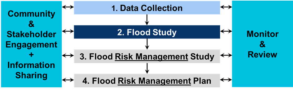
Once a Flood Risk Management Plan is completed, we review old Studies and Plans to update them with the latest information and review how effective they were and make any new recommendations on how to further reduce flood risk.
For more information on flood risk Studies and Plans we are working on, and to view completed studies, please visit our Flood Risk Management page.
How does this impact me?
What is a 'Lot'?
A 'Lot' is the area of land within the boundaries shown on a land title.
Some lots have a single home or business, while others may contain multiple separately owned units, apartments, villas, townhouses or businesses.
Flood studies generally assess flood risks based on the lot because buildings and land use can change over time. This provides a consistent way to understand and manage the flood risk now and into the future.
As a result of this, the number of Lots identified can differ from the number of homes, businesses and owners within the study area.
What if I want to develop my Lot?
Being in either the Flood Planning Area (FPA) or Probable Maximum Flood (PMF) extent does not prevent development and importantly, only the part of a Lot identified as affected by flooding is considered when planning development.
If your property is identified in the Study, additional planning and design requirements may apply to ensure the development can safely withstand flooding and does not increase flood risk for neighbouring properties.
These requirements are outlined in Chapter 40: Environmental Risk – Flood Risk Management of the Sutherland Shire Development Control Plan (DCP). Depending on the type of development and the nature of the flood risk, considerations may include floor levels, building design, structural resilience, vehicle access and evacuation.
We recommend speaking with Council early in the planning process to understand any flood-related requirements that may apply to your property.
If my lot is within the FPA or PMF extents, will I need a flood engineer's assessment for future development? *New*
Once the flood study has been adopted, property owners proposing development on a lot within the Flood Planning Area (FPA) or Probable Maximum Flood (PMF) extents will be able to obtain a Flood Certificate from Council. The certificate provides property-specific flood information, including flood depths, velocities, and flood hazard mapping.
This information can be used to help guide the design and development process, including determining appropriate floor levels and identifying flood flow paths that may need to be maintained to help protect life and property and ensure development does not increase flooding on neighbouring properties.
Whether a flood engineering assessment is required will depend on the type of development proposed, whether the development is within the FPA or PMF extent, whether the proposed development is located within an area of the lot identified as being affected by flooding, and the applicable planning controls.
What does the Study mean for my property?
Flood behaviour can change over time as new studies, improved modelling techniques and additional survey information become available. As a result, areas identified as being affected by flooding may change as flood studies are updated.
Where flood information is available from adopted (not draft) studies, a notation may be included on planning certificates like other potential hazards such as bushfire, landslips, coastal hazards or contamination. These help owners, prospective purchasers and developers understand potential flood risks and any planning considerations that may apply to a Lot.
A property may be identified as flood affected if it is located within the Flood Planning Area (FPA)*, an area used to help guide planning and development. The FPA applies development controls to protect future development of all kinds from the known risks of flooding on a Lot.
The Flood Planning Area sits within the broader Probable Maximum Flood (PMF) extent. This very rare event is used primarily for emergency planning purposes. However, controls are applied for sensitive developments including where vulnerable populations who cannot easily evacuate or respond to emergencies are located. For example, childcare, aged care, health services, or educational facilities. Hazardous facilities that may pose an environmental risk if flooded are also subject to controls.
Being in either the FPA or PMF extent does not prevent development and importantly, only the part of a Lot identified as affected by flooding are considered when planning development.
Will the Study impact my rates?
The Study is not expected to have any impact on your rates. Rates help fund local infrastructure and services based on the property values set by the Valuer General.
Does being identified in the Flood Study affect property values or insurance premiums?
Property values are influenced by a broad range of factors. There is no clear evidence that the adoption of overland flow information on its own would result in a sustained impact on property values.
Each insurance provider has its own risk assessment process used to set premium prices. The Insurance Council of Australia advises that insurers already hold extensive flood risk data. The industry has developed the National Flood Insurance Database (NFID), which insurers use to assess flood risk. In determining insurance premiums, insurers consider NFID data alongside other factors, including building type, location, and claims history.
We cannot rule out that Council's revised draft Overland Flow - Flood Study could impact premiums, however, it is likely it provides more accurate detail than studies conducted by an insurance company.
The standard insurers' definition of flood in Australia is defined in the Insurance Council of Australia's General Code of Practice as: "The covering of normally dry land by water that has escaped or been released from the normal confines of: any lake, or any river, creek or other natural watercourse, whether or not altered or modified; or any reservoir, canal or dam."
Overland flow does not fit into this definition and is sometimes considered as ‘stormwater’ by insurers. However, it is recommended that you speak with your insurer for a full understanding of policy coverage and other types of flood risk at your property.
Further information on flood insurance is available from the Insurance Council of Australia:
Flood insurance explained - Insurance Council of Australia
Floodplain Management Australia partnered with the Insurance Council of Australia in developing three factsheets on flood insurance:
What is a Section 10.7 Planning Certificate?
What is a Planning Certificate?
A Section 10.7 Planning Certificate provides landowners, prospective buyers and developers with information about the planning controls that apply to a Lot. This includes information about land use zoning, development controls and known constraints affecting the land, such as flood risk. Similar notations may also apply for other hazards, including bushfire, landslip, coastal hazards and land contamination.
A notation on a Planning Certificate does not prevent development from occurring. It simply indicates that development on the land may be subject to specific planning controls. If development is proposed, such as a new dwelling, extension or renovation, the flood risk may need to be considered to ensure future occupants can live safely and flood risks are appropriately managed.
Please note that no notations will be applied to planning certificates until the Study is adopted by Council.
- protect the integrity of the feedback by reducing duplicate or automated responses
- ensure each response is counted once, so results accurately reflect community views
- maintain confidence in the data used to inform Council decisions and reporting
- meet governance and reporting requirements for community engagement activities.
- you can receive updates about current and future engagement opportunities
- you can easily return to view or participate in other consultations on the site.
Why do I need to register on the site to respond to the online survey?
Registering on the Join the Conversation website helps Council ensure that feedback is collected in a fair, reliable and transparent way.
Having registered users allows Council to:
Registering also provides some optional benefits:
Your personal details are managed in accordance with Council’s privacy obligations, and you can opt out of updates at any time. Your feedback is still considered even if you choose not to receive communications.